Image Page on the
Philippines
Insert pictures, and at least one panorama image, and a webcam image from two different times.
Outline
- Landscapes
- Batad Rice Paddy Terraces
- Chocolate Hills
- El Nido
- Naidi Hills
- Cities
- Manila, Philippines
- Crowded Street, Manila
- Street Basketball in Manila
- Cebu Carbon Market
- Landmarks
- Fort San Pedro, Cebu
- Malacañang Palace
- Leyte landing Memorial Park
- Baroque Churches of the Philippines
- Images of People
- Surfing Siargao
- Fiesta Time
- Children with the Dead
- Cubao, Quezon City
- Images from the book
- Whale Shark
- Sagada
1 Landscapes
Batad Rice Paddy Terraces
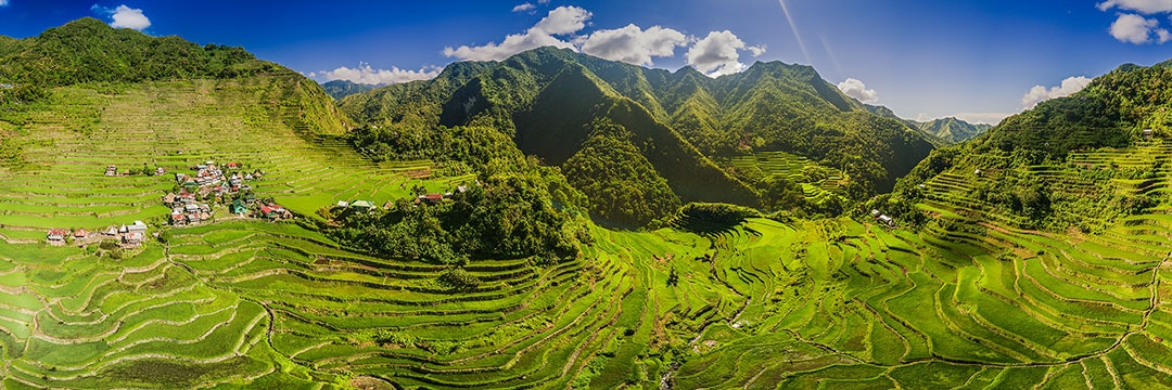
https://www.travelimagez.com/wp-content/uploads/2017/05/Philippines-Batad-aerial-02.jpg
The Batad Rice Paddy Terraces were captured in this panoramic
photo by combining 60 photos shot 360 degrees at three different elevations with
the photographer’s DJI Mavic Drone. These emerald green rice terraces that follow
the contour of their mountains were carved out and passed down from generation
to generation to sustain the cultivation of rice so central to the lives of the
Ifugao people. By harvesting water from the mountaintop forests and creating stone
walls with the ability to hold water necessary for growing rice, they were able
to establish an effective irrigation system to allow for a sustainable method of
land use for the environment.
Chocolate Hills
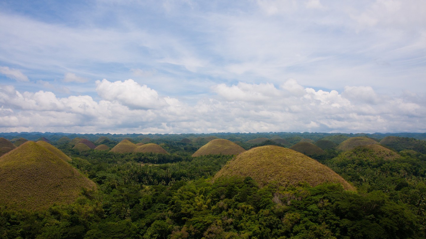
https://theculturetrip.com/asia/philippines/articles/11-places-in-the-philippines-all-locals-are-proud-of/
During the dry season, over the Bohol Island, miles of these
natural formations resembling chocolate mounds are found in the Sierra Bullones
Region. There are approximately 1268 of these grass-covered hills scattered
throughout the area, ranging from 100 to 400 feet tall. They are only viewed as
chocolate during the dry season as their grass is dry and turns to brown to resemble
said chocolate kisses. There are theories that these hills may have been a
result of oceanic volcano activity and limestone weathering, however some have
assessed an uplift of coral deposits or an ancient volcano eruption in
combination with rain water and erosion shaping out the landscape.
El Nido
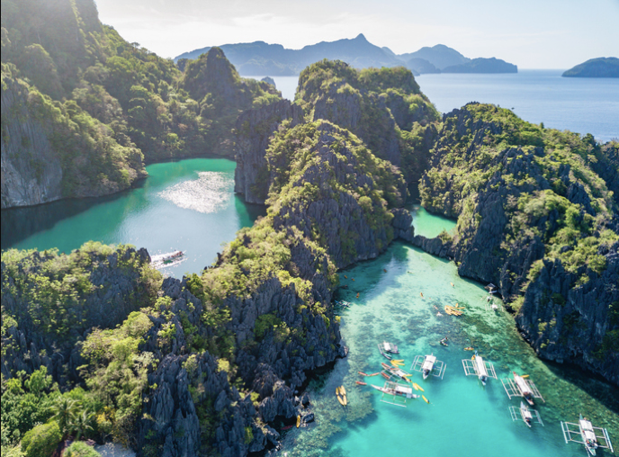
https://filipinotimes.net/wp-content/uploads/2019/05/iStock-990885370.jpg
El Nido is described as the gateway to the Bacult archipelago, located approximately 260 miles southwest
of Manila, this tourist ravaged area is known for its limestone cliffs, white-sand
beaches, coral reefs and azure waters. El Nido has been inhabited as early as 2680
BC as evidence of fossils and burial sites date back to the late Neolithic Age.
During the Song Dynasty, Chinese traders mentioned the island for its abundance
of edible bird nests. On June 17, 1954 the name of the town Bacuit
was changed to its present name El Nido, named after the edible nests of the swiftlets
that are found in the crevices of its limestone cliffs.
Naidi Hills
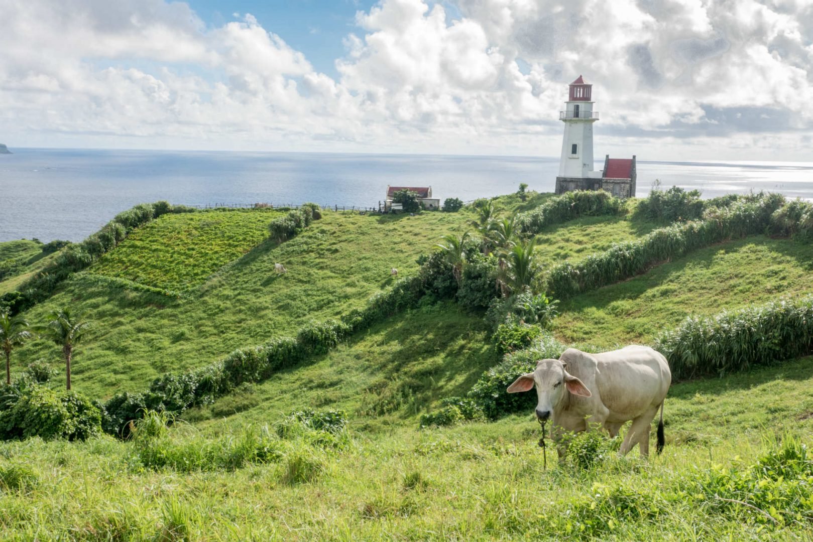
Located about 190 miles north of Luzon in the Luzon Strait is the island of Batan, characterized as rocky and rugged, this area is abundant in lush hills with an open ocean backdrop. The lighthouse in the upper right third of the image is known as the Basco Lighthouse. It is one of the three lighthouses proposed by Congressman Florencio Abad to not only be used as a working lighthouse but attract tourists. This area is also known as one of the first locations of attack by the Japanese Imperial Army bombings at the start of World War II. The buildings that have survived in the area have been converted to businesses to cater to the growing popularity of the area from the lighthouse.
2 Cities
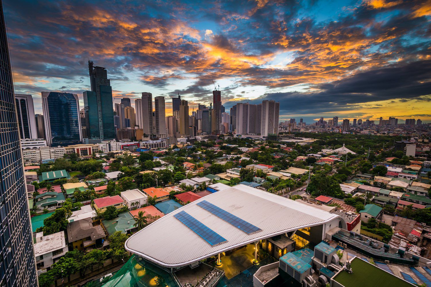
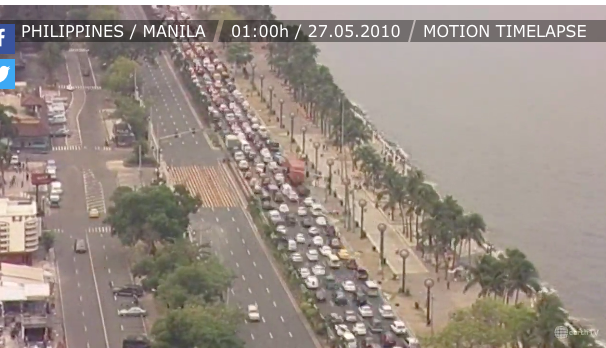
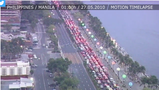
Manila, Philipines
https://s29745.pcdn.co/wp-content/uploads/2019/12/Airbnbs-in-Manila-Philippines-2020.jpg.optimal.jpg
https://www.earthtv.com/en/webcam/manila-bay-roxas-boulevard/timelapse
The last of the days sunshine peaks through scattered clouds
in the photograph above. A distinct contrast is exhibited in this photo of
Manila, where approximately two thirds of the image is the Legazpi Village surrounded
by towering skyscrapers that make up the Manila Business District. Further in
the background is another cluster of skyscrapers which could possibly be the nearby
city of Quezon. It is interesting to note the village and city captured in the
same frame as it creates a sort of juxtaposition between the two worlds. The
following webcam images are photos lapsed within an hour featuring Roxas Boulevard. From this time lapse, the viewer is able
to notice the non-stop traffic of many citizens leaving the city. As dusk turns
to nighttime, the colorful street lights along with cars tail lights paint a different,
visually entertaining scene. This scene is reminiscent of the oceanside street
on West Palm Beach or really any tourist lined street next to a popular beachfront
in Florida.
Crowded Street, Manila
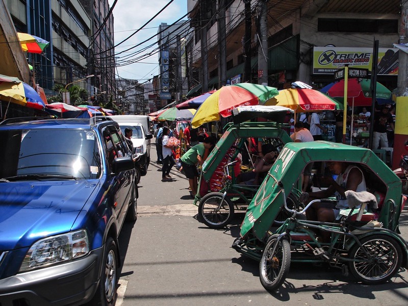
We are given a street view perspective of what it may look like for someone walking the car-filled, bike-taxi, vendor- filled streets of Manila. Busy would be an understatement but a reality of why taking a taxi or renting a car many not be the most time-efficient manner of traveling throughout the city. This labyrinth of street vendors and market-goers appears to be endless in this photo. This image was taken with an Olympus E-PL1 at an ISO of 200, 14.0 mm, 1/250 and a relatively medium aperture at f/9.0
Street Basketball in Manila
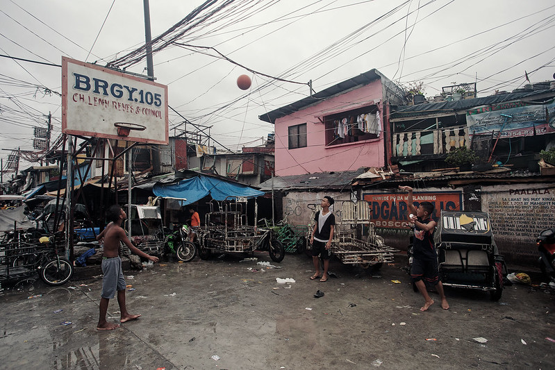
Boys playing basketball on the street in Manila are depicted in this image. Someone may notice the make-shift roofs, tangled powerlines and trash littered throughout their playing area however in this shot, the boys are simply fixated on the whether or not they will make the shot into the basket. This image depicts the conditions that many people in the Philippines live with. This brings to questions the division of society in the Philippines and leads us to think about the different social and cultural environments within the Philippines. While a percentage of the younger population has moved to the city to pursue a job or career, others are susceptible to an inevitable cycle of poverty and financial struggles that perpetuate a standard of living in areas as depicted in the image above.
Cebu Carbon Market
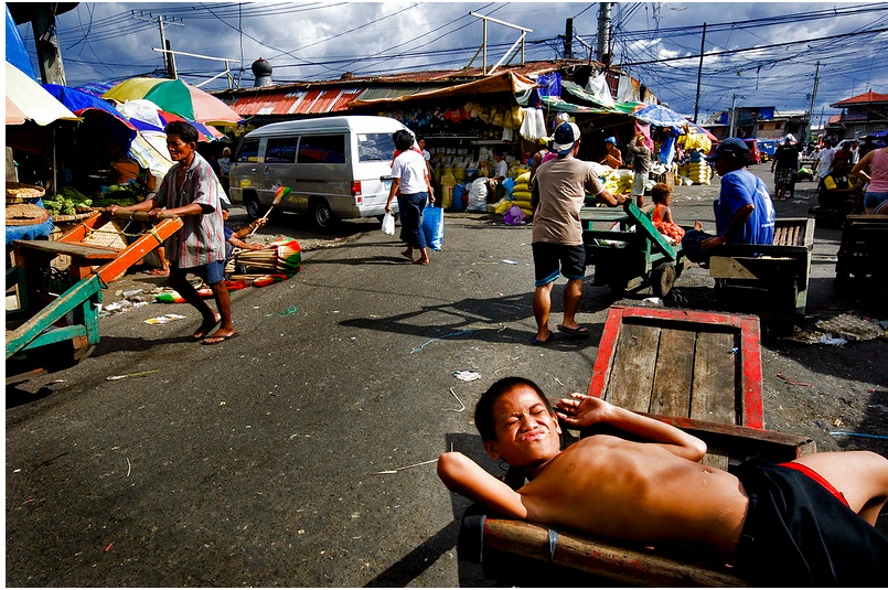
https://www.flickr.com/photos/ramdiboy/3085920008/sizes/c/
Photographer Mio Cade captured this photo on his travels to
the Philipines. Shot in Cebu city, a boy lays indolently
on a fruit crate as the people behind him go about their day. His lack of shirt
and sun tanned skin hint at the climate and temperature of the day. The man
behind him pushing a wooden cart is even more sunburnt which may hint at
working long hours outside, exposed to the sun. Another factor to note is the
abundance of yellow colored rice bags
stacked neatly along the outside of the market in the background.
3 Landmarks
Fort San Pedro,
Cebu
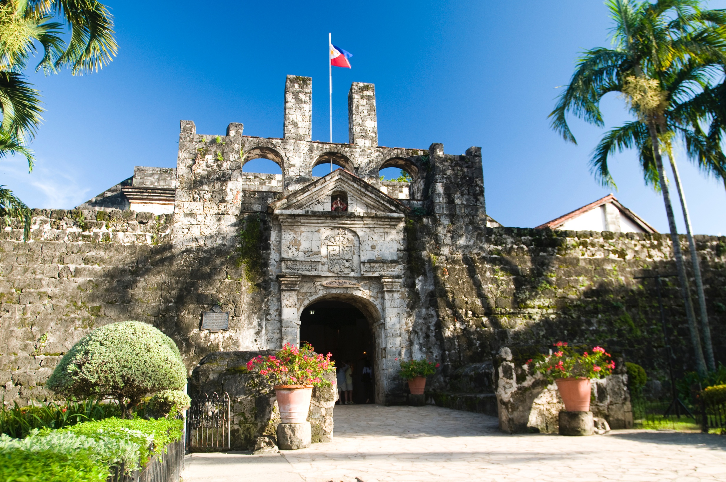
https://lp-cms-production.imgix.net/2019-06/2d75ea363a6f384e85a9ab0263a9f4d1-fort-san-pedro.jpg
Fort San Pedro was established in 1565, built by Spaniards under the command of Miguel Lopez de Legazpi. Although the original fort was crafted from wood, the stone fort replaced it around the 17th century to protect against Muslim raids. Ultimately, the fort seen today and in this image was completed in 1738 and is the oldest bastion fort in the country. During the Philippine Revolution it served as a stronghold for Filipino Revolutionaries. Fort San Pedro was formerly an army garrison, rebel stronghold, prison camp and even city zoo.
Malacañang Palace
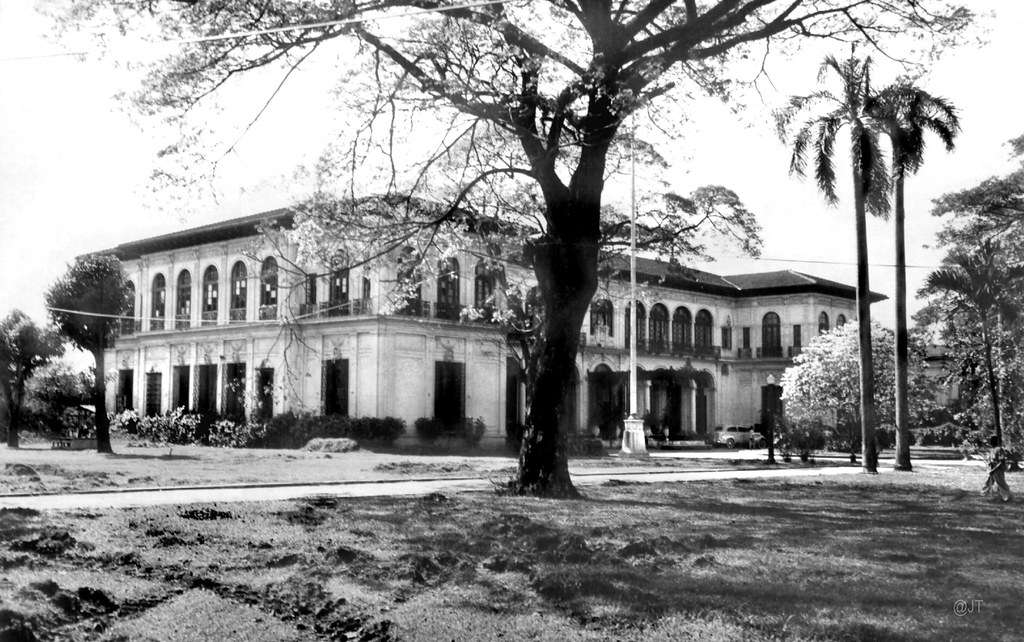
https://live.staticflickr.com/8190/8129906295_f7fef54456_b.jpg
Malacañang Palace is home to the President of the Philippines. It serves as both the official residence and primary workplace of the President, similar to our White House. Located in San Miguel Manila, this structure was originally constructed in 1750 by Don Luis Rocha as a summer home along the Pasig River. This black and white image creates a timeless quality about the home. An interesting fact is that this structure has been home to 18 Spanish governors, 14 American military and civil governors, and in 1953, became residence for the President of the Philippines on the establishment of the Commonwealth of the Philippines on November 15.
Leyte Landing Memorial
Park
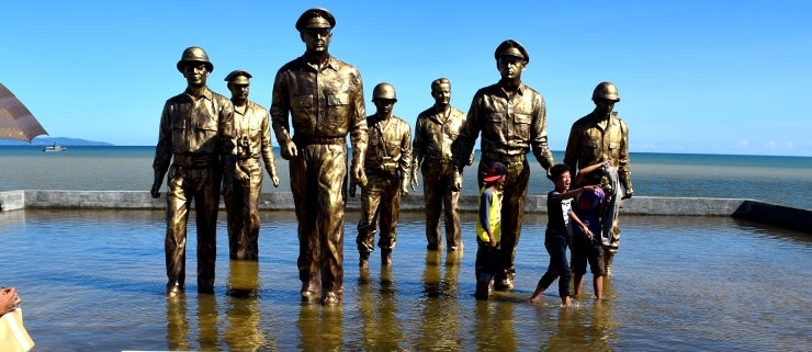
https://faq.ph/wp-content/uploads/2015/12/Leyte-landing-monument.jpg
Seven bronze statues commemorating the landing of General Douglas
MacArthur in Leyte gulf stand among two young boys playing in the shallow
manmade pool. Located on Leyte island in Eastern Visayas, this site is
commemorative of the historic A-Day Landing as captured in a photo by Gaetano
Failace. Annually, local and foreign dignitaries along with war veterans and
their families attend this site to commemorate the recapture and liberation of
the Philippines from Japanese occupation on 20 Oct 1944. The series of events
unfolded one of the world’s largest naval battles during WWII.
Baroque Churches of the
Philippines
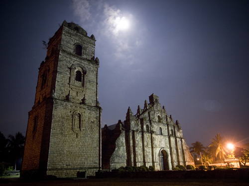
https://whc.unesco.org/uploads/thumbs/site_0677_0014-500-375-20131017115440.jpg
There are four baroque chirches in
the Philippines built by the Spanish in the late 16th century. They
are located in Manila, Santa Maria, Paoay and Miago-ao. This particular church is the Miagao
Church also known as the Santo Tomas de Villanueva Parish Church, designated as
a UNESCO World Heritage site in 1993. In this particular image, the brightness
of the moon along with the artificial light from the street lamp play opposites
in both warm and cool characteristics to the photograph. It was taken with an interesting
perspective as the tower on the left looms over the main entrance of the
church.
4 Images of People
Surfing Siargao
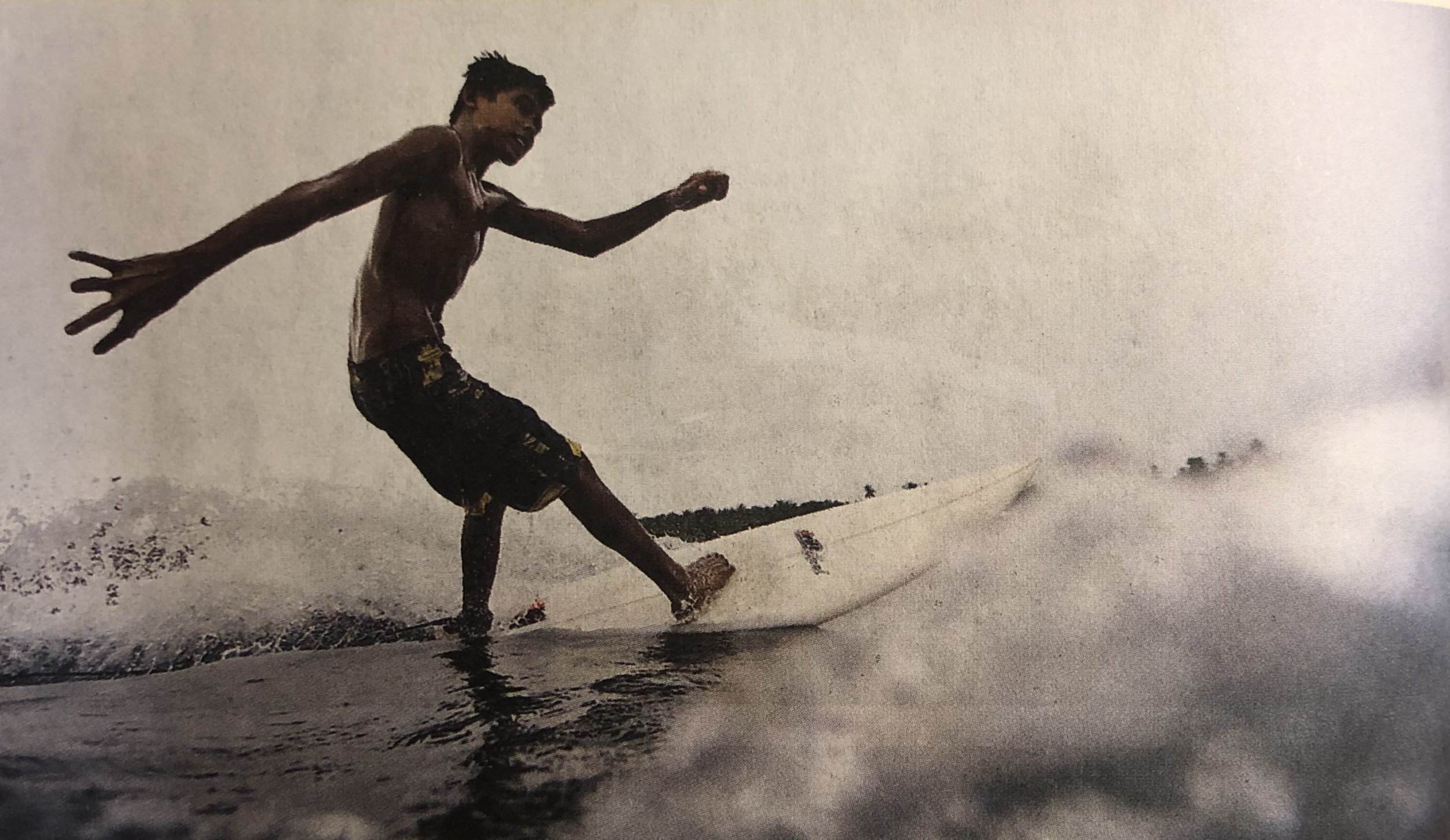
Bloom,
Greg. Lonely Planet: Philippines, 2012. Lonely Planet, 2012.
Surfing
is a popular past-time for both locals and tourists, young and old, novices to
skilled veterans that visit the island of Siargao. I
imagine this image must have been very difficult to capture because it seems
the subject is in very close proximity, almost dodging away from the camera. It
must take a lot of skill to be able to balance and stay horizontal on your board
as the force beneath pulls against you. The water that is out of focus in the
forefront of the image makes for a more dynamic as well as interesting image.
Fiesta Time
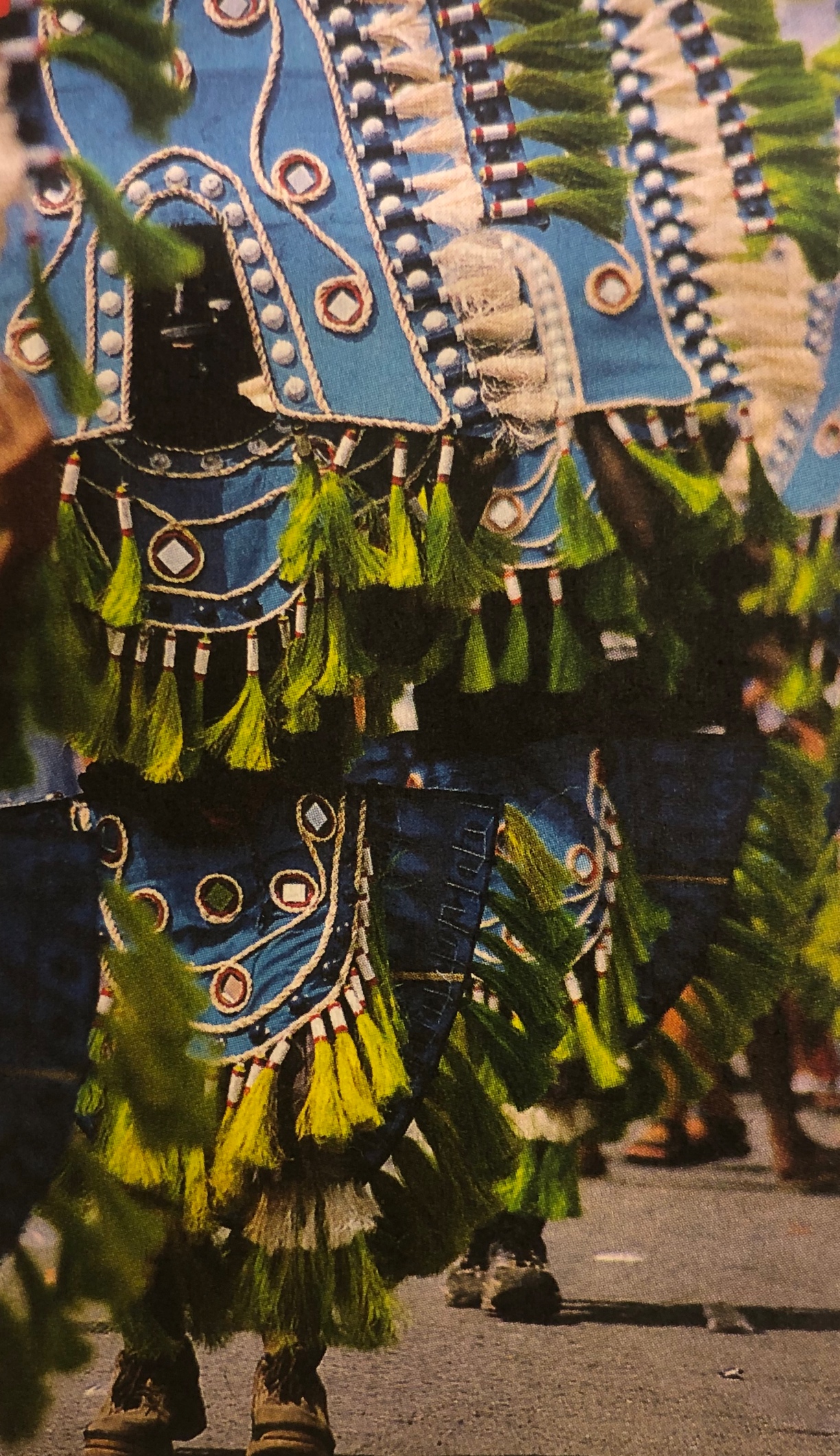
Bloom, Greg. Lonely Planet:
Philippines, 2012. Lonely Planet, 2012.
A central part of the Philippine culture are the various
annual celebrations otherwise known as fiestas. In this image, a line of masked
men will eventually sweep crowds into dancing frenzies. According to my book, the
Philippines’ most popular and riotous festival is that of Ati-Atihan, these
festivals can last from one day to one week and are compared to Mardi Gras or
Carnaval. White and chartreuse tassels line the arc shaped pieces that provide
movement and an electric pop of color to the azure main pieces of regalia.
https://www.flickr.com/photos/ecogarden/1428716842/in/photostream/
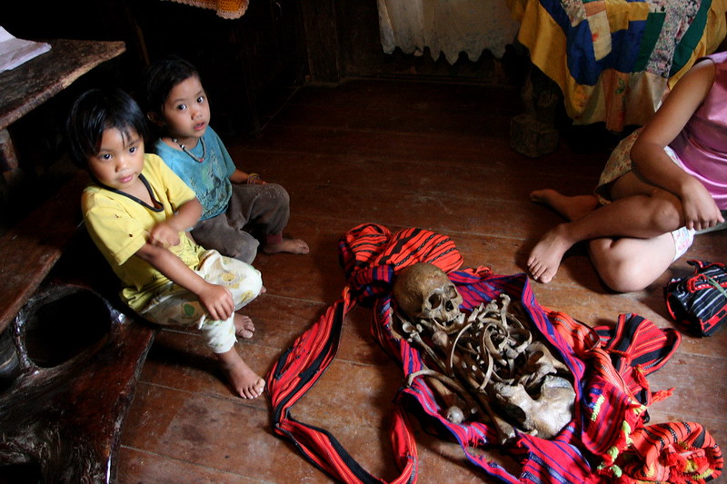
Two young children and a woman on the left sit around an unwrapped skeleton. The children are dressed in simple clothes, holey and mud-stained and do not seem to mind the human skeleton that may have been a deceased relative or someone close to their family. When it comes to honoring the dead, different regions within the Philippines have different customs, the one most similar to what may be occurring in this photo may be that of the Ifugao. The Ifugao people practice Bogwa which is the practice of exhuming the bones of the deceased individual, cleaning and rewrapping them then returning them to the grave.
Cubao, Quezon City
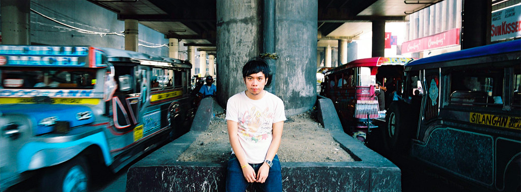
A young man positions himself center of the image on the
median in between two lanes of inbound and outbound jeepneys on Katipunan Avenue
in Quezon City. Jeepneys recognized by their colorful, kitschy decorations are
the primary means of public transportation in the Philippines. They are unique
to Filipino culture and art, and Quezon City is an epicenter of the latest
trends in music, art, culture and food as it is also home to many universities like
the University of the Philippines and Ateneo de Manila University which
attracts many young adults such as the man in the photograph.
5 Images from the
Book
Whale Shark
Bloom, Greg. Lonely Planet:
Philippines, 2012. Lonely Planet, 2012.
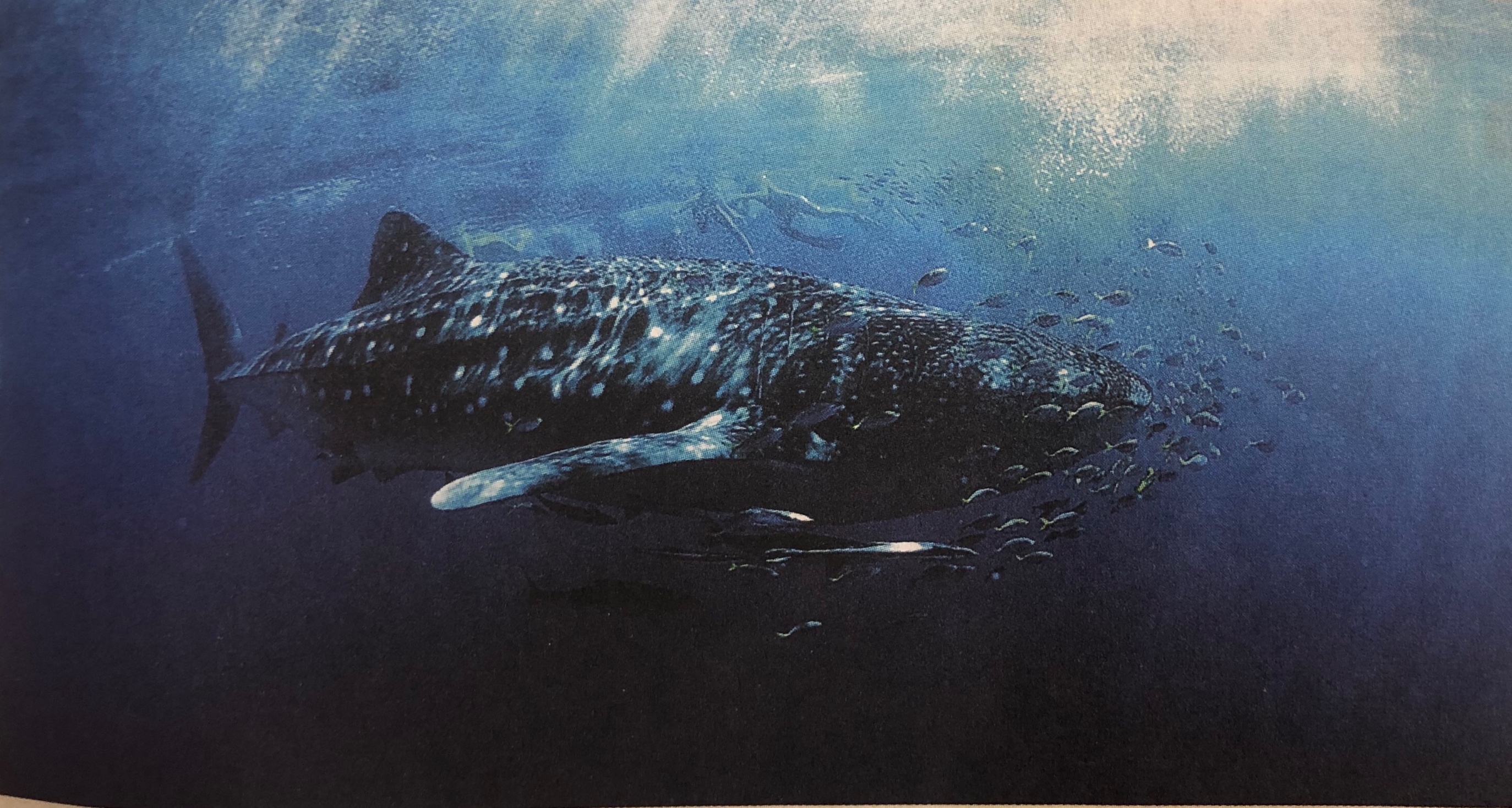
The Philippines are home to a gentle giant, the whale sharks. Known to be one of the largest fish in the world, it attracts tourists from far and wide, which is great for big tourism but terrible for the species. Some claim that it is possible to view these whale sharks in a sustainable, natural way and promote staying away from popular tourist areas in addition to raising awareness of the detrimental effects that popular tourist companies impose on this species. Although the whale is a protected species and it is illegal to harass them in the Philippines, it is very difficult to control/regulate and people still continue to break those laws.
Sagada
Bloom, Greg. Lonely Planet: Philippines, 2012. Lonely Planet, 2012.
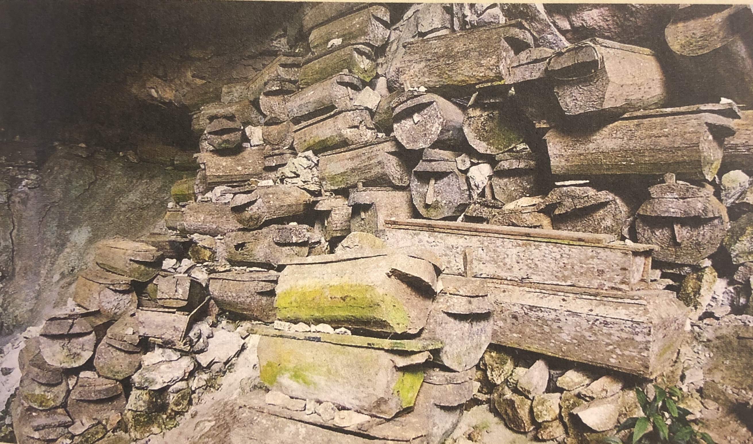
A unique burial method as exhibited in the photo above is known as the Lumiang Burial Caves in Sagada, this involves stacking coffins into niches cut into the lichen covered rocky cliffs. Over 100 coffins are stacked at the entrance of the cave and the oldest is assessed to be about 500 years old. These stacked coffins offer a view into the culture of the tribes of the Cordillera of North Luzon, they depict just how their deceased are treated and exemplify their values.
Submitted by Suzanne Lopez on 10 April 2020.